Kayaking the Mississippi from Pakenham north to Mohr’s Road
On April 25, 2020 Molly and I kayaked north on the Mississippi, starting in Pakenham at 5 span bridge park, following instructions in the Paddle Routes of the Ottawa Valley guide for the Mississippi River - Pakenham to Hwy 17 section and the Mississippi River - Hwy 17 to Ottawa River but stopping at the island before the Galetta power station where Tanya picked us up.
The highlight of the trip was exploring two side creeks, Cody Creek and Cartright Creek I think, according to the Paddle Routes of the Ottawa Valley. Definitely a nice paddle, nothing spectacular though.
I don’t seem to have bene running my fitness tracker, so here’s my reconstruction of the route:
My camera lens was a little dirty for the first half of this trip but I fixed that after it got knocked off my kaya in Cartright Creek, after which I had it head mounted.
Need to know
- Who: any level of paddlers - kayaks best for the side creeks
- Where: put in at five span bridge park in Pakenham. You need to arrange someone to pick you up or plan to retrace your steps - the current is not noticable so it should not be hard getting back upstream.
- When: any time of year I think… we went in early srping with high water, the creeks may not be navigable all year?
- What: fairly scenic trip down the Mississippi with two side creeks
- Why: scenery… no significant wildlife though
Putting in
There’s a boat simple boat launch at five span bridge park you can use. Lots of parking as well.
Five Span Bridge
The currents are strong immediately downstream of the Five Span Bridge (to your right as you leave the launch) but drop off immediately. Here’s a shot of the bridge and the park/putin location:

Cody Creek
The entrance to this creek was a couple of kilometers up on the right, we were looking for it based on Paddle Routes. Even so we almost missed the overgrown entrance, and we there was barely room for our short 10’ kayaks to maneouver into the creek.

It’s a very twisty and narrow creek, fun to zip around in. This is the point we turned around - there were some logs across the creek and Molly said it was getting down to a trickle at that point anyway.
By the time we decided to head back, it was impossible to turn our kayaks around so we had to go in reverse.
Mississippi
Nothing to complain about the view heading downstream from Cody Creek.


A trio of dogs greeted us from the shore, and one looked like it was going to swim to meet us but turned around… the water can’t have been much about freezing.

Cartright Creek
We might have missed this creek if we hadn’t been looking for it, and I’m glad we found it. This is what the entrance looked like when we were there in early spring:

It’s a bigger creek than Cody. Once we were in the creek there were several fallen trees we had to lug our kayaks around. On the whole it looked really nice!

Here’s where we turned around - we could have kept going but time was pressing:

Both Cody and Cartright seem to be deep channels cut out of a much wider channel that must be underwater earlier in the spring.
Highways
Once we were back on the Mississippi, we were within sight of highway 3 (Upper Dwyer Hill Road).
Once past 417 the 17 is immediately visible in the distance:

As we approached the 17 we saw an artifical bunch of bird nests beside a barn that we later learned was the Ottawa Valley Canoe and Kayak Shop.

A few days later we bought ourselves a third kayak at the shop so three of us could head out at once. We found out what birds the nests were for… but we have since forgotten. Anyway it’s a charming shop, run out of an old barn.
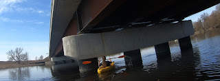
Highway 17 is the most fun of the three bridges because you can turn the pillars into a (difficult!) obstacle course.

Downstream of 17
We found two more creeks to explore just downstream of the 17, but we had to leave those for another day.
I ran out of batteries for my camera for the final stretch to the island above the dam. We followed the instructions in the Paddle Routes guide and stayed to the left of the island. The current was very strong near the bridge to the island on that side… I basically got sucked under the bridge and had to beat pretty hard to stay right and get onto the island there. Molly got out of her kayak and onto the island without braving the bridge.
There were quite a few people about on the island, including a woman on a large pony.
Final thoughts
This was a lovely paddle, mostly because of the creeks. We liked it so much we came back a few days later to hit the two creeks we had to skip after highway 17.
We had been worried that it would be too much to paddle back upstream which is why we had Tanya pick us up. In retrospect, it would have been no problem at all to paddle back up to Pakenham.


No comments:
Post a Comment